 ADSCivil
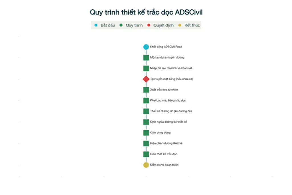
The longitudinal profile design process in ADSCivil Road
Introducing ADSCivil Road and Longitudinal Profile Design
ADSCivil Road - A Professional Design Tool
ADSCivil Road is professional road design software developed by BaezeniSoft, covering every design stage from preliminary design through construction to as-built documentation. It supports the design of expressways, urban streets and mountain roads alike, with full integration between horizontal alignment, longitudinal profile and cross section design.[2][3][4]
Its strengths in longitudinal profile design include generating the existing ground profile from terrain data, designing the proposed vertical alignment automatically using optimisation algorithms, setting out vertical curves to the technical standards, and integrating with the drainage system. It also supports work on existing roads, with level optimisation to minimise earthwork quantities.[3][5][6]
Why Longitudinal Profile Design Matters
The longitudinal profile is a diagram showing how the level of the route changes along its length, describing the terrain along the alignment including high points, low points and gradients. Its design not only keeps vehicles moving safely but also fixes the position of ancillary structures such as bridges and culverts, ensures effective drainage, and optimises earthwork quantities.[7][8][9]
In urban road design, the profile must keep the formation level below natural ground so that rainwater can drain into the road during heavy storms. On mountain roads, the profile must follow the terrain closely to reduce earthwork volumes and maintain slope stability.[3][10]
The Longitudinal Profile Design Process in ADSCivil Road
Preparation
Before profile design can begin, the full set of input data is needed: a terrain map at a suitable scale, geotechnical survey data, and information on control points such as bridges, culverts, intersecting roads and existing structures. The horizontal alignment must be fully designed with the horizontal curves sensibly laid out.[11][4][7][12]
Defining the profile band template is an important step in ensuring the drawing meets the standard requirements. The template should include chainage, existing ground level, design level, design gradient, distances and information on ancillary structures.[11]
Generating the Existing Ground Profile
The first step is to generate the existing ground profile from the terrain data. ADSCivil Road uses the TD command to do this, automatically taking levels from the 3D terrain model at each chainage along the route.[11]
Once generated, the display settings need adjusting: horizontal and vertical scales, the colour of the existing ground line, text sizes and the profile band information. Horizontal scales of 1:1000 to 1:2000 are typical, with vertical scales of 1:50 to 1:200 — the vertical scale usually exaggerated ten times relative to the horizontal.[7]
Designing the Vertical Alignment
Drawing the Proposed Vertical Alignment
Designing the vertical alignment is the heart of profile design and is carried out with the DD command in ADSCivil Road. It requires setting levels according to design principles, using a grade-following approach, a cut-through approach, or a combination of the two.[11][16][12]
The principles to follow are: respect the levels at control points; use even gradients with few changes; keep gradient sections no shorter than 150 m; avoid abrupt gradient changes; and keep the formation level at least 0.5 m above the top of any culvert. In cut, the minimum longitudinal gradient is 0.5%; in fill it may be 0%.[11]
Optimising the Vertical Alignment
ADSCivil Road provides vertical alignment optimisation (the TUDD command) to calculate the optimal design levels automatically and so minimise earthwork quantities. This is particularly useful when upgrading an existing road, as it finds the design level that minimises the additional fill area required.
To use it, the cross section parameters must be fully defined: carriageway width, cross fall, shoulder width and pavement thickness. The result is only a suggested alignment; the engineer still needs to adjust it to comply with the technical standards.[6]
Vertical Curve Design
Setting Out Vertical Curves
Vertical curves are placed at gradient changes to give a smooth ride and extend sight distance. ADSCivil Road uses the CCD command to design them, calculating parameters such as radius, curve length and levels at the key points automatically.[12]
The software supports two main types of vertical curve: circular and second-degree parabolic. The parabolic curve is generally preferred because it gives a smoother transition.
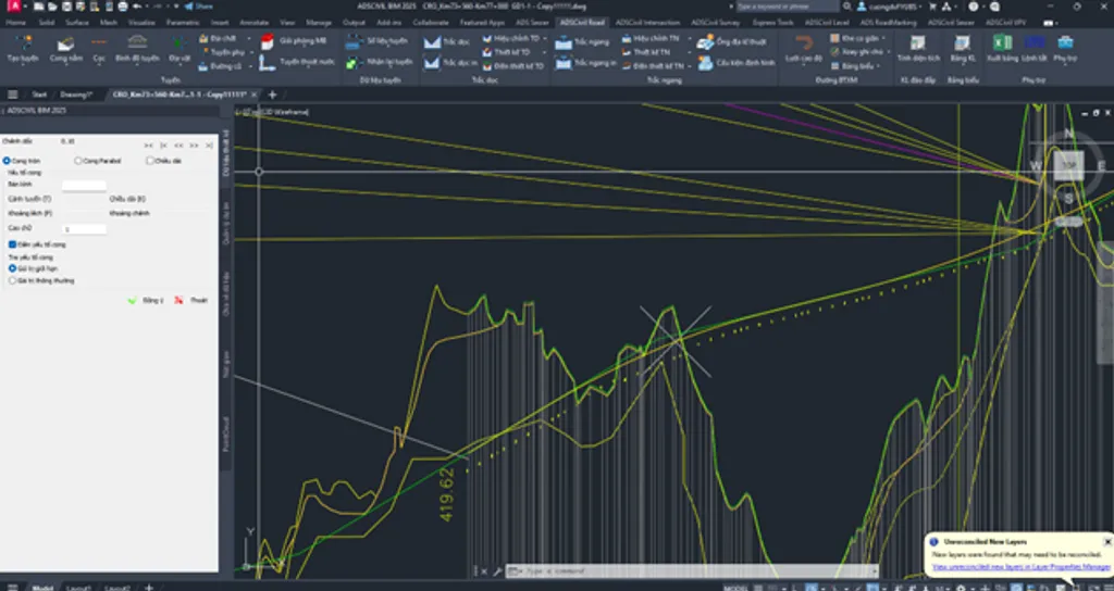
Setting out vertical curves in ADSCivil
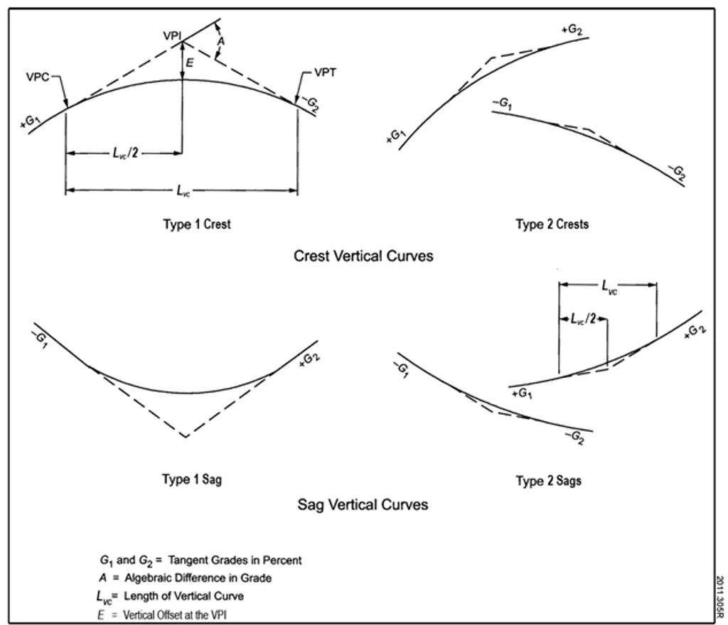
An illustration of the crest and sag vertical curves used in highway engineering, showing the key parameters: tangent gradients, curve length and level difference.
K-values are looked up automatically against the design standard to ensure safe stopping sight distance.
Checking Against the Technical Standards
Vertical curve design must comply with the standards for minimum radius, minimum curve length and sight distance. Under TCVN 4054:2005, the vertical curve radius depends on the design speed and the algebraic difference in gradients. The minimum curve length is typically three times the design speed, for appearance and ease of construction.
Crest curves must provide stopping sight distance, while sag curves must provide headlight sight distance at night. ADSCivil Road includes built-in K-value lookup tables for both international and Vietnamese standards.
Completing the Design
Populating the Profile Band
Once the vertical alignment and curves are complete, the DTK command populates the profile band with the design values. It automatically calculates and displays the design level at each chainage, the gradient of each section, the curve lengths and other geometric parameters.
This must be done carefully to ensure the figures are accurate, particularly where ancillary structures occur. ADSCivil Road updates the values automatically whenever the design is revised.
Checking and Correcting
The final stage is a comprehensive check of the design, verifying technical parameters such as gradient section lengths, the algebraic difference between adjacent gradients, minimum gradients and standards compliance. Particular attention is needed where the route crosses other structures, and the control levels must be respected.[11]
ADSCivil Road produces automatic check reports flagging design errors such as breaches of the minimum radius, excessive gradients or overly short straight sections. Corrections should be made systematically so as not to affect other parts of the design.[12][11]
Advanced Tools and Features
Integration with Drainage Design
ADSCivil Road integrates profile design with the drainage system through ADSCivil Sewer. This is particularly important on urban roads, where longitudinal gradients are often very shallow and drainage depends entirely on the side ditch as adjusted in the profile design.[3]
The system automatically controls culvert invert levels, maintains the minimum cover and optimises the drainage network. Synchronising road and drainage design avoids clashes and keeps the works buildable.
BIM Design Support
ADSCivil Road exports 3D BIM models, allowing earthwork quantities to be calculated accurately by geological stratum. The BIM model helps detect design clashes early and supports more effective project management.[5]
Generating a 3D longitudinal section complete with information on structural layers, geology and buried services makes it easy for stakeholders to understand and assess the design. This is especially useful on complex projects with many different strata.[5]
Applicable Technical Standards
TCVN 4054:2005 - Highways
TCVN 4054:2005 is the principal standard for highway design in Vietnam, setting out the requirements for new construction, rehabilitation and upgrading. It divides roads into six technical classes, I to VI, each with its own requirements for design speed, curve radius and longitudinal gradient.
For profile design, TCVN 4054:2005 specifies the maximum longitudinal gradient, gradient section lengths, vertical curve radii and sight distance requirements. Maximum longitudinal gradients typically range from 3% to 8% depending on the road class and terrain.[9]
International Standards
ADSCivil Road also draws on international standards such as AASHTO in the United States and European standards for vertical curve design. The formulas for K-values and minimum radii are standardised on research into driver psychology and physiology.
The stopping sight distance standard is built on driver reaction time (usually 2.5 seconds), the coefficient of friction between tyre and road surface, and driver eye height (1.08 m). ADSCivil Road has these values built in so it can check automatically and suggest appropriate design parameters.
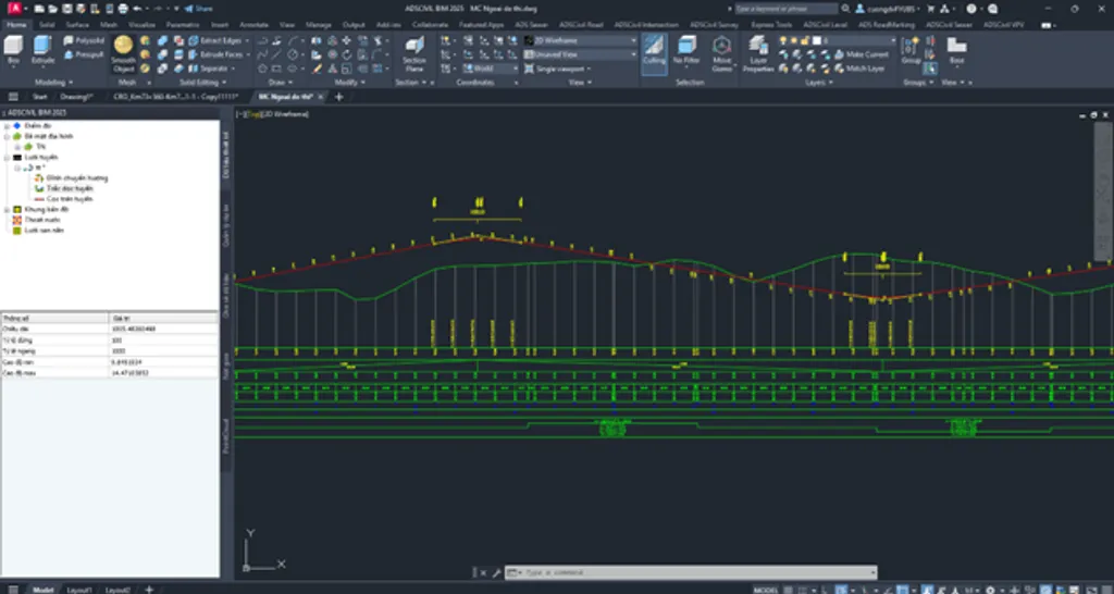
Longitudinal profile design and geometric data visualisation in ADSCivil Road for highway engineering.
Step-by-Step Guidance
Starting Up and Setting Up the Project
To begin profile design in ADSCivil Road, start the software and create or open a project. The coordinate system, units and basic project parameters must be set carefully to ensure accuracy throughout the design.[2]
Terrain data is imported into the project as level points, contours or a 3D model. ADSCivil Road supports a range of formats including DWG, DXF and GIS formats. Checking the quality of the terrain data is an important step in avoiding design errors.
Setting Up the Alignment and Chainages
The horizontal alignment must be fully designed before the profile is generated. ADSCivil Road uses it as the basis for taking existing ground levels at each chainage. Generating chainages at the standard interval — typically 20 m or 25 m for detailed design and 50 m for preliminary design — should be done systematically.[4][7]
Additional chainages should be inserted at special locations such as changes in terrain, cross culverts and intersections with other roads. ADSCivil Road allows chainage positions to be adjusted automatically or manually to suit the specific design requirements.[7]
Carrying Out the Vertical Alignment Design
Analysing the Terrain and Choosing a Strategy
Before drawing the vertical alignment, the terrain should be analysed carefully to settle on the right design strategy. On flat ground, shallow gradients can be used to ensure drainage. In hilly terrain, grade-following and cut-through approaches must be combined to optimise earthwork volumes.
Identifying control points — bridges, culverts, intersections with other roads — is a key factor shaping the vertical alignment. ADSCivil Road allows these control points to be defined and displayed on the profile to support the design.[11][7]
Technique for Drawing the Vertical Alignment
When using the DD command, take care to choose start and end points consistent with the control levels. The alignment is best drawn section by section, grouping stretches of similar terrain so gradients are easier to control.[12]
ADSCivil Road supports several ways of drawing the alignment: directly with the mouse, by entering exact coordinates, or by copying an existing polyline. Each has its own advantages and suits particular design situations.
Optimising Vertical Curves
Choosing Vertical Curve Parameters
Choosing the vertical curve radius means balancing technical and economic requirements. A large radius gives good sight distance and a smooth transition but increases earthwork volumes. A small radius saves cost but may compromise safety and appearance.[12]
ADSCivil Road suggests radius values based on the technical standards, but the engineer can still adjust them to suit the particular conditions. Parameters such as T (tangent length), P (mid-ordinate) and K (curve length) should be checked carefully.
Coordinating with Horizontal Curves
Where a vertical curve coincides with a horizontal curve, particular care is needed to coordinate them for appearance and safety. The point of vertical intersection should coincide with the apex of the horizontal curve, or be offset by no more than a quarter of the curve length.[11]
ADSCivil Road checks the coordination between plan and profile automatically and warns when there is a problem. The 3D visualisation lets the engineer assess how well they work together at a glance.[2][5]
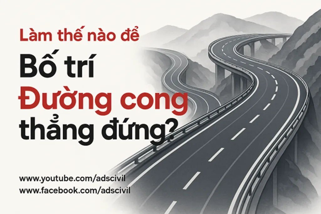
How vertical curves are arranged in road design - illustrated with a worked example.
Handling Special Cases
Designing Road Upgrades
For upgrading an existing road, ADSCivil Road provides dedicated tools for optimising the design. The vertical alignment optimisation feature finds the design level that minimises the volume of additional material. Defining both the existing and the new pavement structure allows the software to calculate the thickness of the additional layers accurately.[3][6]
When designing an upgrade, particular attention must be paid to tying in with the existing road and providing sensible transition gradients. ADSCivil Road can simulate staged construction so that traffic is not interrupted.[6][3]
Designing in Difficult Terrain
For mountain terrain with steep gradients and many strata, ADSCivil Road provides specialised tools. Designing side slopes that vary by stratum helps ensure stability. The automatic sight distance check takes both horizontal and vertical curves into account to ensure safety.[3]
Earthwork quantities are calculated by stratum automatically and with high accuracy, supporting accurate cost estimates and sound construction planning.[5]
Quality Control and Output
Automatic Checking
ADSCivil Road includes automatic checking to catch common design errors such as breaches of the technical standards, clashes between design elements, or mismatches with actual conditions. Real-time warnings help the engineer find and fix problems early.[2]
Detailed check reports give information on each problem found together with a suggested remedy, improving productivity and reducing design risk.[2]
Producing Drawings and Reports
Once the design is complete, ADSCivil Road produces drawings to both Vietnamese and international standards. Automatic sheet splitting to standard paper sizes optimises printing and document storage.
The reporting system automatically generates quantity schedules, chainage coordinate tables, geometric parameters and other technical information. These reports are pre-formatted to the requirements of the approving authorities and can be exported in a variety of formats.[5]
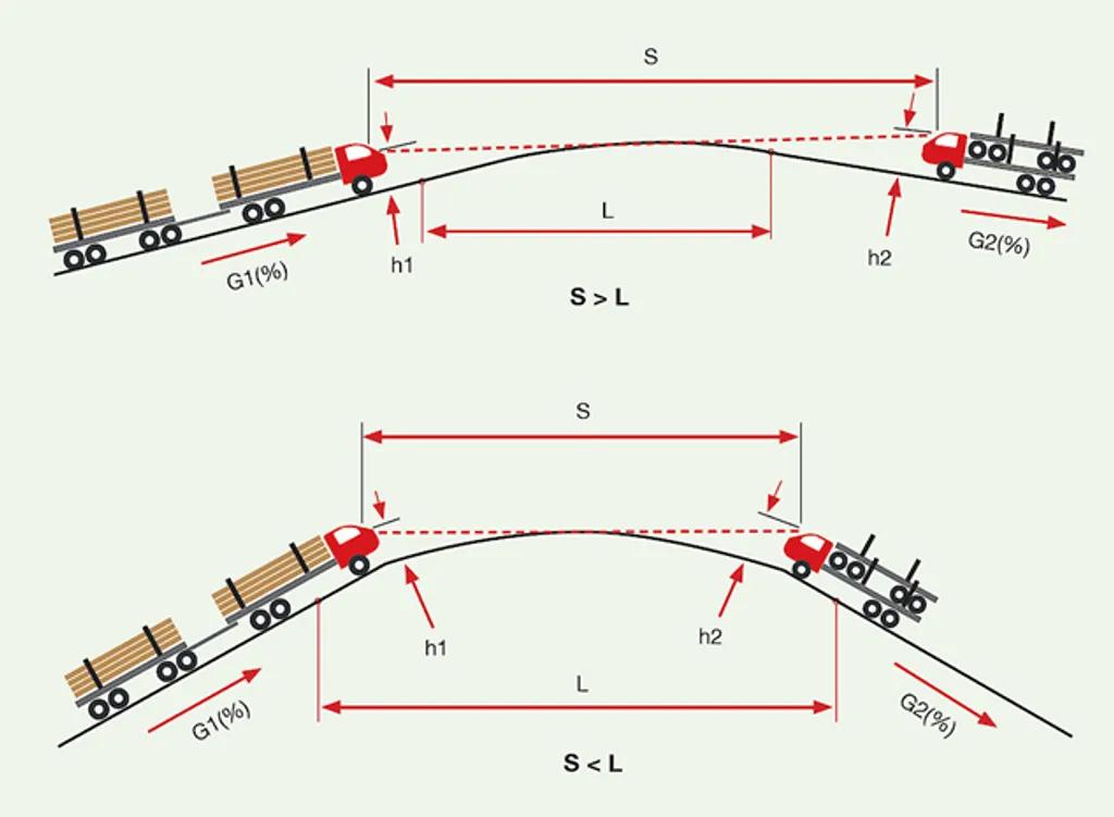
A diagram illustrating vertical alignment with curves, comparing horizontal distance against curve length and showing how gradient affects vehicle level.
Integration with Other Software
Linking with ADSCivil Survey
ADSCivil Road integrates closely with ADSCivil Survey for processing survey data and building the terrain model. Automatic updating from new survey data keeps the design based on the most accurate information available.
The survey point management system tracks the provenance of each piece of data and controls the quality of the input. This matters particularly on large projects with several rounds of supplementary survey.
Connecting to BIM Software
ADSCivil Road exports models to common BIM formats such as IFC, allowing integration with other software in the design workflow. Sharing the 3D model with other disciplines helps detect clashes early and optimise the overall design.[5]
Synchronising data between applications keeps the design information consistent. Automatic updating when the design changes saves time and reduces errors.[5]
Practical Points and Experience
Optimising the Workflow
To get the most out of ADSCivil Road, establish a standardised workflow from data preparation through to design completion. Creating templates and standard libraries saves time and ensures consistency.[2]
Regular training for the engineering team on new features and advanced design techniques is important for productivity. Sharing experience between team members helps avoid repeating common mistakes.[2]
Data Management and Backup
Data management must be set up carefully to avoid losing important information. ADSCivil Road provides automatic backup and version management to track design changes.[2]
Naming files and folders to a defined convention makes projects easier to search and manage. Rules on access and editing rights should be established for security and quality control.[2]
Conclusions and Recommendations
Longitudinal profile design in ADSCivil Road is a complex process demanding both deep technical knowledge and fluency with the tool. A comprehensive review of its features and design workflow confirms that ADSCivil Road provides a complete, professional solution for road profile design.[1][2][3]
It is not simply a drafting tool but a fully integrated system spanning survey data processing, automated design using optimisation algorithms, quality checking and standards-compliant output. Integration with the wider ADSCivil ecosystem — Survey, Sewer and Intersection — creates a coherent and efficient design environment.[2][3][5]
Its earthwork optimisation, 3D BIM design and support for road upgrading in particular meet the real needs of Vietnam's transport construction sector. This allows engineers to design roads that are not only safe and efficient but also economically and environmentally optimal.[3][5][8][6]
To realise the software's full potential, however, organisations need to invest in structured training and establish standardised workflows. Keeping up to date with new technical standards and advanced design methods is likewise important in maintaining design quality.[2]
Looking ahead, advances in BIM and artificial intelligence will continue to be built into ADSCivil Road, opening up new possibilities in road design and optimisation. This means the engineering community must keep learning and adapting to new technology in order to stay competitive.
- https://www.youtube.com/watch?v=UqH8WYNrtOQ
- https://adscivil.com/v2/blog-detail?id=adscivil-roaden
- https://adscivil.vn/v2/blog-detail?id=adscivil-roaden
- https://www.youtube.com/watch?v=Y6UZHyh6ihQ
- https://adscivil.vn/v2/blog-detail?id=constructing-cut-and-fill-volumes-in-road-alignment-bim-models
- https://www.youtube.com/watch?v=RzOFUH2pcA8
- https://openjicareport.jica.go.jp/pdf/12269627_04.pdf
- https://www.youtube.com/watch?v=Lg_HfprSHCs
- https://www.youtube.com/watch?v=__OQrJt9Os0
- https://www.youtube.com/watch?v=-kV1yFrxiiQ
- https://adscivil.vn/blog-detail?id=khai-bao-mau-bang-trac-doc
- https://adscivil.vn/blog-detail?id=ve-trac-doc-tu-nhien