
×
![]()

ADSCivil Sewer - is an application of professional drainage network design for urban areas and industrial zones, fully meeting the design stages:
- Preliminary design
- Technical design
- Construction drawing design
- As-built drawing design
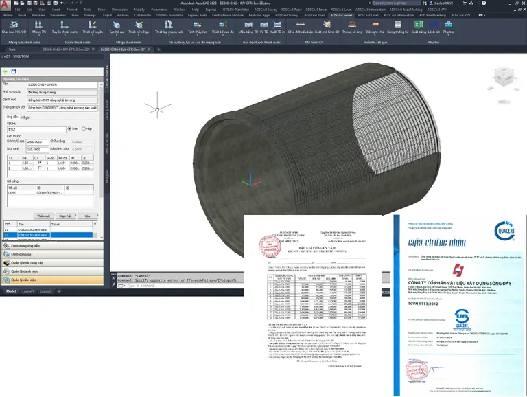
LIBRARY OF COMPONENTS
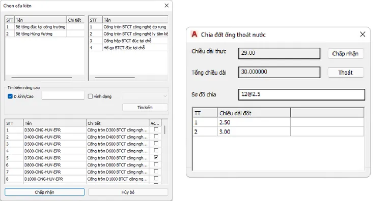
- A default library of available components on the market is integrated in ADSCivil Sewer. All types of sewer pipes or manholes can access accurate information about an available model on the market, ensuring their origin and supplier information.
- Components in the library of the shaped blocks are all set up to exact technical parameters. This helps users to reduce the time spent searching for the dimensions of the components in the manufacturer's catalogs.
- The relevant documents of the components such as price quotation, test results, quality certificates, etc. can be easily downloaded from the library. They can be attached as an integral part of the submission report of materials in the design documents.
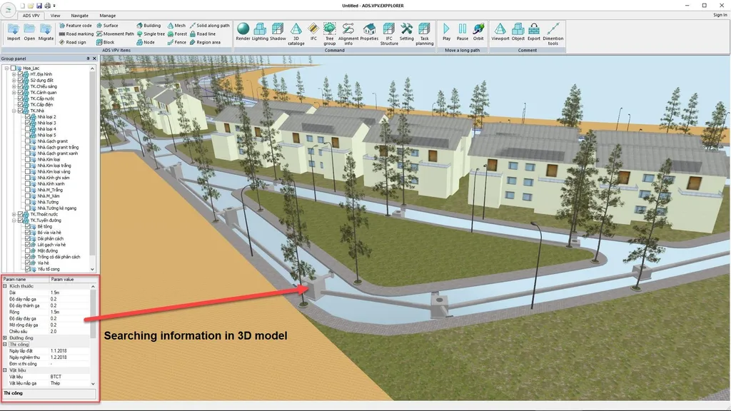
- ADSCivil Sewer not only provides 2D drawings but also automatically references to 3D models containing full components information and automatically integrated into the information model on ADSCivil VPV.
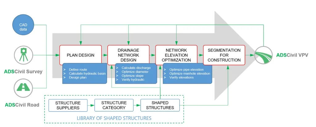
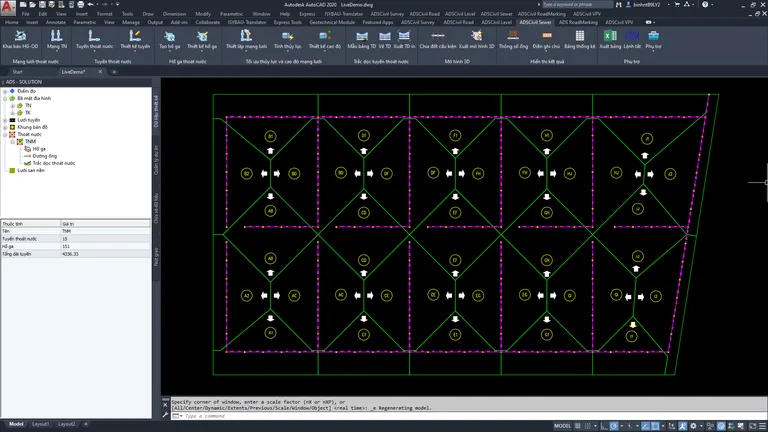
DESIGN OF NETWORK DRAINAGE
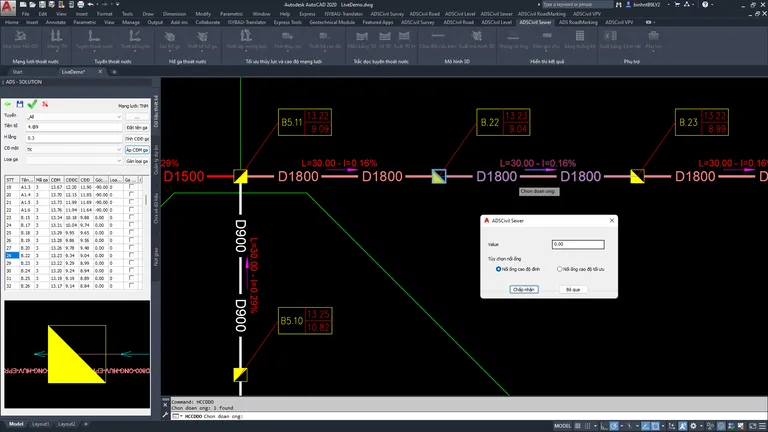
- An infrastructure drainage network can be designed by ADSCivil Sewer. This is the primary distinction between ADSCivil Sewer and other tools which typically only declare the geometric designs of a single drainage path or simply add-ons to export the longitudinal profiles of the pipeline based on the longitudinal profile features of route design software.
- The ADSCivil Sewer design principle is to ensure automatic updating and synchronization between manholes and pipes both in the network and at drainage path intersections. Until now, ADSCivil Sewer is the first and unique software dealing with the problem in Vietnam.
- Because of the data architecture designed for the network, the new ADSCivil Sewer version can get intelligent features such as:
+ Automatically check errors for each design position in the drainage network.
+ Automatically calculate the cumulative discharge according to the water flow direction of the drainage network.
+ Search, measure, and assign drainage basin area to each manhole and pipe segment in the drainage network.
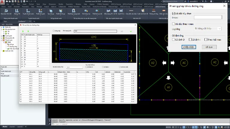
HYDRAULIC CALCULATION
The current drainage standard is deeply integrated into ADSCivil Sewer to make the hydraulic calculation of the stormwater network easier than ever. This work used to take a lot of effort, such as looking up a series of tables and graphs, calculating the optimal iteration. With ADSCivil, it is reduced to just a few operations:
- It can automatically calculate the area of the drainage basin on drawings; allocate and assign an area for each manhole, and pipe segment of the network.
- The built-in tables, which are used for looking up parameters and are integrated in ADSCivil Sewer, make it simple to calculate the required discharge with the selection of the project's construction site. The whole process of setting up the calculation parameters will be done automatically to determine the required discharge for each pipe segment.
- The optimal calculation of pipe diameter and slope is done automatically. ADSCivil Sewer will recommend the most suitable pipe type from the library.
- ADSCivil Sewer also allows users to calculate the maximum network discharge that can be drained based on the specific allowable density of the stormwater or wastewater network. This feature also allows determining whether any designed network meets the drainage requirements.
ELEVATION OPTIMIZATION — ELEVATION DESIGN SYNCHRONIZATION
The stage of designing the elevation of the drainage network must ensure harmony and rationality throughout the network. In the design process, it is always necessary to control the following factors:
- The buried depth of the pipeline must ensure the minimum thickness of the pipe protection layer.
- Reducing the buried depth of pipe (especially at the end of the network) should be a priority in order to reduce the volume of earthwork.
- The elevation of the inlet and outlet of pipes at the manhole position must comply with the principle of connecting pipes according to the top, bottom, or water level connection.
- The elevation of the designed road surface and the level of the ground are inherited to be used as the manhole surface elevation automatically.
Complex problems are solved in a fully automatic way in ADSCivil Sewer. Moreover, ADSCivil supports network elevation control and adjustment and re-updates in just a few steps.
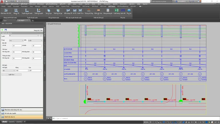
EXPORT AND PRINT RECORD RESULTS
Exporting and printing record results is always the strength of the software in the ADSCivil suite. ADSCivil Sewer always affirms its superiority in exporting and printing records in the most efficient way.
- Export the longitudinal profile of the drainage path in the network with all content meeting the requirements of the drainage drawing's specialized standards.
- Link and reference the data of the road piles with ADSCivil Road for construction deployment.
- Paginate to print the longitudinal profile of the drainage path into standard or optional paper sizes.
- Export the drainage plan chart automatically according to the printed paper size.
COMPONENT SEGMENTATION AND BIM MODEL EXPORT
- For each section of pipeline or manhole, ADSCivil Sewer automatically recommends the optimal segmentation scheme according to the length. Designers can immediately use the scheme or can also adjust some segments to suit actual conditions.
- Direct export of 3D data for information integration model on ADSCivil VPV.
Pricing
Choose a service package that suits your requirements and budget, from flexible daily solutions to long-term investments
Other products
Expand your vision, elevate your project with a comprehensive toolkit for every construction challenge.